The Texas Low Income Housing Information Service (TxLIHIS), an NLIHC State Coalition Partner, will conduct a webinar presenting mapping strategies for advocates working on fair housing. Mapping is a way to create and present a better understanding of neighborhood conditions and use this understanding to influence public policy around disparities in services to low income and minority populations.
The webinar will explain how Texas advocates use geographic data to address disinvestment and environmental hazards. Participants will be able to submit stories or questions for discussion with the panelists.
The webinar will take place on Wednesday, May 27 at 3:00 pm ET.
Register for the webinar at http://info.policymap.com/mapchats
Webinar presenters will be TxLIHIS co-founder John Henneberger, and TxLIHIS fair housing planner Charlie Duncan.
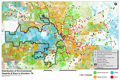
The map below is an example of TxLIHIS’s mapping work. It shows environmentally hazardous sites in the Houston area, and indicates how these sites are predominantly concentrated in minority neighborhoods (the area outlined in black is the majority white part of Houston called “The Arrow”). This type of analysis assists TxLIHIS’s partners in Houston, the community leaders at Texas Organizing Project, as they push for local policies to address racial and environmental inequalities.

